Now Reading: Hurricane Erin forecast to bring life-threatening surf and rip currents to East Coast
-
01
Hurricane Erin forecast to bring life-threatening surf and rip currents to East Coast
Hurricane Erin forecast to bring life-threatening surf and rip currents to East Coast
By Marlene Lenthang, NBC NEWS
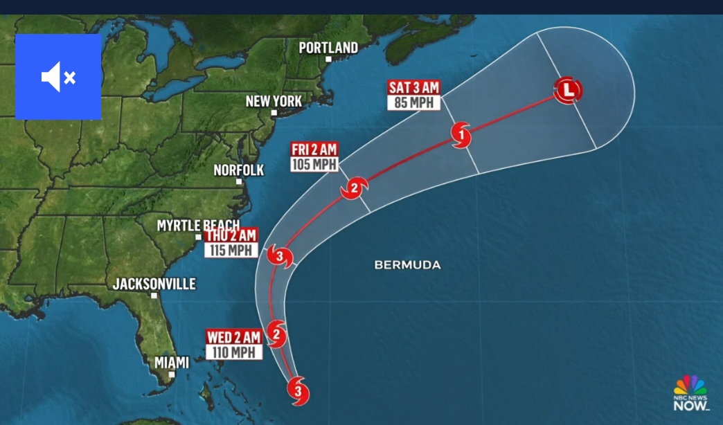
Hurricane Erin reduced its fury late Monday and returned to Category 3 potency, but was still expected to bring potentially deadly waves and rip currents to the East Coast midweek.
Erin was 780 miles south-southeast of Cape Hatteras, North Carolina, with maximum sustained winds of 125 mph and a northwest path clocked at 8 mph, according to the National Hurricane Center’s late-night update Monday.
Those wind speeds fell from Category 4 status earlier in the day, settling the cyclone back down to Category 3 en route to its eventual dissipation as it moves north over cooler, open-ocean waters.
In the meantime, however, the hurricane center warned that the storm could continue to fluctuate in force and will likely remain a Category 3 hurricane, if not stronger, through midweek.
The category is defined by 111 to 129 mph sustained winds and is the gateway to “major” storm status that also includes categories 4 and 5, the latter reserved for the most potent cyclones.
“Fluctuations in strength are expected during the next couple of days,” the hurricane center said in the last regular Erin advisory for Monday. “However, Erin is likely to remain a dangerous major hurricane through the middle of this week.”
Calling the storm “unusually large,” forecasters with the center said in an earlier advisory that Erin is expected to pass by parts of the Bahamas on Monday night through Tuesday before turning north and spinning between the U.S. East Coast and Bermuda.
The center issued storm surge and tropical storm watches for a large section of North Carolina’s coast. The Outer Banks could begin getting storm conditions Wednesday, the center said.
The storm is expected to churn out hurricane-force winds that extend 80 miles, according to the hurricane center.
A tropical storm warning is in effect for the Turks and Caicos Islands and the southeast Bahamas, and a tropical storm watch is in effect for the central Bahamas.
Erin was forecast to produce heavy rainfall across parts of Hispaniola on Monday and in the Turks and Caicos and parts of the southeast and Central Bahamas through Tuesday. Two to 4 inches, with locally higher amounts of 6 inches, are forecast.